| |
|
|
| |
2.5.1 Keeping in
view the basic ideals of the township and the innovative approaches being
developed in Auroville, the land-use structure is based on the following
premise:
|
|
The built-up area, consisting of buildings and developments for
residential, cultural, manufacturing, commercial and utility uses,
international pavilions and open spaces, would evolve around the
Matrimandir with its gardens in the centre of the township.
|
|
; |
The largely unbuilt part consisting of agricultural uses, regener
ated forests, tanks, water bodies, channels and a number of green
activities linked to the promotion of sustainable development, would
encircle the built-up area and also act as interface between the
City and its bio-region.
|
|
|
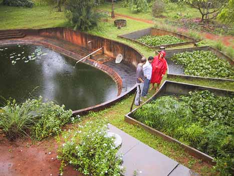
| |
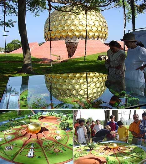
Matrimandir with its development proposals
|
|
| |
2.5.2 The
vision behind Auroville's planning and development right from its conception
to the present day is that there will be an intense and close interrelationship
between the City Area and the outside rural area, including the Green
Belt, which will be of a synergical nature. Each would complement the
other, and support the activities in the 'urban' and 'rural' sectors,
thus reducing the urban and rural divide that has crept into urban planning
so far, and encouraging a rural - urban continuum.
|
|
| |
2.5.3 Land
Use in the City Area: In view of the concept discussed earlier, the City
Area is proposed to have the Peace Area with the Matrimandir, the Banyan
Tree, the Lake, the Amphitheatre and the Gardens in the centre and the
following use zones around it:
|
|
Residential Zone |
|
|
International Zone |
|
|
Industrial Zone |
|
|
Cultural Zone |
|
|
| |
2.5.4 There is another
special use zone, which traverses all the four zones in a concentric fashion
with a width of about 75 meters, consisting of a circular road with buildings
facing it. This is termed as the 'Crown Area'. This Crown area will provide
most of the service facilities required to support the activities in the
four zones mentioned above. The developments in the Crown area will naturally
be somewhat different, depending upon its proximity or interface with
each zone. For the purposes of zoning regulations, the crown area is considered
as a separate zone under each of the four zones.
|
|
| |
2.5.5 The basic principles
/ parameters adopted in land use planning are given in Table
11.
|
|
|
Table 11 : Principal Planning
Policies
| Sector of Development |
Planning Policies / Parameters
|
| 1. |
Residential |
Maximum living space per person: 30 sqm Range of densities
and interesting architectural forms 50% unpaved area as
permeable space Collective and community use Eco friendly
practices in water and energy management Pedestrian and
cycle ways Harmonious landscaping and tree planting
|
| 2. |
Industrial |
Clean, non-polluting industries Small and medium scale
Expand local employment Vocational training for youth Encourage
local entrepreneurship Good working environment for workers
Efficient management practices
|
| 3. |
Education and Culture |
International studies on Humanity Indian / East-West Culture
Synthesis of knowledge Arts, craft and technology
|
| 4. |
International |
International pavilions for cross country exchange Science
and technology Culture, philosophy and humanities
|
| 5. |
Building Development |
Innovative, low energy consumption, cost-effective technology,
eco-friendly, barrier-free architecture, indigenous materials
|
| 6. |
Water |
Water harvesting Watershed management Waste water recycling
Aquifer storage and recovery Preventing saline intrusion
Water conservation
|
| 7. |
Energy |
Use of solar, wind and biomass energy Better demand and
supply side management
|
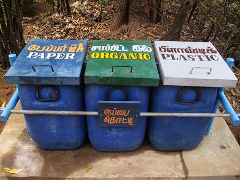
| 8. |
Solid waste |
Segregation at source Composting and recycling Special
disposal of hazardous and biomedical waste Attaining zero
garbage situation
|
| 9. |
Traffic and Transport |
Exclusive pedestrian and cycle paths Encouraging non-polluting
traffic Service nodes for interface with villages Designing
non-polluting vehicles
|
| 10. |
Health |
Synthesis of a wide range of medical knowledge Emphasis
on indigenous systems Good healing practices
|
| 11. |
Green Belt |
Healthy productive employment Field laboratory for best
practices in eco-friendly techniques Environmental sustainability
Food security Developing urban-rural linkages
|
| 12. |
Bio region |
People’s participation in sustainable development Improving
sanitation and water supply Improving housing through cost-effective
techniques Innovative research programmes Better agriculture
practices
|
|
|
|
| |
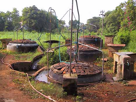
Bio Gas production : Alternative energy
 |
|
| |
2.5.6 The proposed land
uses zone wise are detailed out in Table
12 and depicted in the Drawing
6 of the Proposed Land Use.
The proposed land use in the green belt is indicated in Table
13 and the re-grouping of the land uses as per the general
land use classification is given in Table
14.
|
|
|
|
|
Table 12 : Proposed Land
Use Zones - 2025
(City Area / Developed Area)
| Use Zone |
Area in ha. |
% |
Principal Uses |
|
| Peace Area |
28 |
5.7 |
Matrimandir, Lake, Gardens |
| 1. Residential Zone |
173 |
35.2 |
|
| |
160 |
32.6 |
Residential houses, apartments
in five sectors at different densities, and basic community
facilities.
|
| Crown |
13 |
2.6 |
Shopping, utilities, communication,
recreation and community facilities of higher order, supporting
residential use.
|
| 2. International Zone |
68 |
13.9 |
|
| Pavilions |
63.5 |
12.9 |
National and international pavilions,
conference and exhibition halls.
|
| Crown |
4.5 |
1 |
Utilities, communication, shops
and other common facilities related to the main activity in
the International Zone, including housing and staff quarters. |
|
| Use Zone |
Area in ha. |
% |
Principal Uses |
|
| 3. Industrial Zone |
126 |
25.7 |
|
| Economic |
94.5 |
19.3 |
Non-polluting manufacturing units,
including cottage industries.
|
| Crown |
8.5 |
1.7 |
Hostels, dormitories, guesthouses
and supporting facilities for the main activity in the zone.
|
| Administration |
7 |
1.4 |
Town Hall, City Administration
offices and housing.
|
| Vocational training |
16 |
3.3 |
Vocational training centres, research
institutions including laboratories.
|
| 4. Cultural Zone |
96 |
19.5 |
|
| Major cultural |
91 |
18.5 |
Educational Institutions, University,
sports centres and staff quarters. |
| Crown |
5 |
1 |
Shopping, utility, communication
and recreation centres and related facilities supporting cultural
activities in the zone, including housing. |
|
|
|
| |
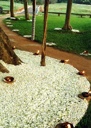
Peace Area
|
|
Table 13 : Proposed Land
Use in the Green Belt - 2025
| |
Area in ha. |
% |
Principal Uses |
Built (*)
(Existing settlements to be retained)
|
156 |
10.5 |
Auroville Communities and Village Residential Areas, Service
Nodes and utilities and main access roads.
|
| Unbuilt |
1316 |
89.5 |
Farming and Forest type uses and recreation, bird & wild
life.
|
Note(*): The existing settlements in the proposed
Green Belt are subsidiary to agriculture, forestry, plantation,
land development and as such they are proposed to be retained
in the future development of Auroville township. However, there
would not be any substantive extensions in these settlements
not related to principal use. Similarly, the existing village
settlements are also part of the built up area and would require
to be retained.
|
|
|
|
|
|
Table 14: Detailed Land
Use in City Area - 2025
| Use |
Extent
in Ha |
% |
Remarks |
1. Residential
|
121 |
24.64 |
Residential Zone 80% Other zones
|
| 2. Commercial |
20 |
4.1 |
Mostly in Crown Area connecting
the zones |
3. Industrial
|
56 |
11.4 |
Industrial Zone/Manufacturing units |
4. Public & Semi-public
|
159 |
32.38 |
|
a. Matrimandir
|
28 |
5.7 |
Peace Area |
b. Pavilions
|
38 |
7.73 |
International Zone |
c. Educational
& Cultural
|
73 |
14.86 |
Cultural and Residential |
d. Administration,
utilities
& other uses
|
20 |
4.07 |
Industrial and other zones |
5. Open space & recreation
|
46 |
9.36 |
To be provided in all zones |
| 6. Transport & communication |
89 |
18.12 |
To serve all zones |
|
|
|
| |
2.5.8 Land
Use in the Green Belt Zone: The
unbuilt area in the Green Belt Zone will have three broad categories of
land use, viz. Agriculture and Farming, Forest and Land Regeneration and
Recreational areas. Their development is designed to promote bio-diversity,
environmental restoration, land regeneration, water management, and technology
transfer of the above activities for wider application. This will make
the Green Belt not only an asset to Auroville and the surrounding villages,
but also a National Resource Centre (NRC) for sustainable development.
|
|
| |
(a) Agriculture and Farming
The western part of the Green Belt, consisting of eris, natural
drainage channels and village settlements, is reserved for intensive agricultural
development. They cover approximately 500 ha. At present these lands are
vacant or marginally used. They will be utilised to set up prototype farms
for raising appropriate crop varieties that can be efficiently produced
in differing geographic conditions in Tamil Nadu, in order to replicate
them for the benefit of farmers in these areas. The geographic regions
will correspond to the five-fold traditional regional classification in
Tamil Nadu of Kurinji, Mullai, Marudam, Neithal and Palai.
Auroville's ongoing work in water management, soil conservation, organic
farming and seed collection, which is being carried out in collaboration
with state, national and international research institutions and agencies,
will promote food security and optimise the agro-economic potential both
locally and nationally.
|
|
| |
(b) Regenerated land
and plantations
The eastern part of the Green Belt, which has already been developed
with dense plantations of trees, acts as a barrier against cyclone-strong
winds coming from the coast, which were until recently the main cause
for soil erosion, gully formation and degradation of land.
These lands occupy about 560 ha. They will be utilised to strengthen
the ongoing work of land regeneration, to re-establish indigenous forest
vegetation, to propagate biodiversity through gene pools and seed banks,
and to institute zero-runoff parameters and practices. This part of the
Green Belt will also serve the Auroville township by carrying out waste
water treatment and recycling, solid waste management and experiments
for producing alternate energy through the use of biomass and wastes.
In this regard Auroville is already collaborating with state and central
government agencies.
|
|
| |
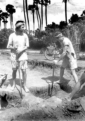
Planting trees in the green belt
|
|
| |
(c) Recreation
Another purpose of the Green Belt is to provide open-air recreational
facilities for the inhabitants. An extent of 256 ha. has been designated
for this purpose, which will also include a botanical garden and agro
and social forestry for the benefit of neighbouring villages. Within this
zone, a modern burial and cremation site is also proposed.
|
|
| |
Water management
|
|
| |
2.5.9 The summary of
uses in the green belt along with implementing partners is given in
table 15.
|
|
|
Table 15: Summary of Uses
in the Green Belt
| Main Uses |
Implementing partners * |
| 1. |
Agriculture and Farming
> Water management
> Aquifer storage and recovery
> Soil conservation
> Farming including organic farming
> Climatic promotion
> Fisheries
> Village development & service nodes
> Agro- & social forestry
|
Auroville groups:
>Auroville Farm Group
>Auroville Green Work
Resource Centre (AGRC)
>Water Harvest, Palmyra
>Auroville Village Action
Group (AVAG)
> Land Use Coordination
Collaborating Partners:
| > |
Tamil Nadu State Council for Science and
Technology |
| > |
Govt. of India Development Research Corporation |
| > |
National Wasteland Development Board |
| > |
AME (The Netherlands), DANIDA (Denmark) |
| > |
GIFRID (German-Israel Govt. Collaboration) |
| > |
Stichting De Zaaier (The Netherlands) |
| > |
DFID (UK), South East Asia Seed Bank |
|
| |
Main Uses
|
Implementing partners *
|
| 2. |
Forest and Land Regeneration
| > |
Indigenous forests |
| > |
Sacred groves |
| > |
Biodiversity park |
| > |
Medicinal plants |
| > |
Dairy, orchards |
| > |
Zero runoff practices |
| > |
Waste water recycling |
| > |
Solid waste recycling |
| > |
Alternative energy |
| > |
Energy plantation |
| > |
Vegetables, flowers |
| > |
Building & road material & transport technology |
| > |
Village service node |
| > |
Technology transfer and dissemination
|
|
Auroville groups:
| > |
Auroville Green Work Resource Centre |
| > |
Palmyra Pitchandikulam Bioresource Centre |
| > |
Shakti, Water Harvest |
| > |
Auroville Centre for Scientific Research
(CSR) |
| > |
Auroville Building Centre Land Use Coordination
|
Collaborating Partners:
State Council of Science and Technology State Dept. of
Environment, Forest & Rural Development Ministry of Environment
& Forest National Wasteland Development Board Rajiv Gandhi
Drinking Water Mission HUDCO, NBO, BMTPC, MNES, Andaman
Ecological Team, UNCHS, European Commission, SWISSAID, GTZ,
GATE, KFW, BORDA (Germany), German Agro-Action, Commonwealth
Human Ecology Council (CHEC), INERP Association Scientifique
(France) Threshold Foundation (US), Stichting de Zaaier
(The Netherlands), Canada Fund, ICEF (Indian- Canadian Environment
Facility)
|
| |
Main Uses
|
Implementing partners *
|
| 3. |
Recreation
> Botanical gardens
> Poultry farm
> Burial and cremation site
> Village service node
|
Auroville groups:
> AGRC
> AVAG
> Land Use Coordination
Collaborating Partners:
> State and GoI Departments of Environment
> Rural Development
|
* Indicates principal partners
who are at present involved in such activities. It is anticipated
that there will be additional collaborating partners as Auroville’s
activities increase.
|
|
|
| |
Solid waste recycling
 |
|